Imaging Solutions

At Io Aerial, we provide high definition aerial photography, videography, and other imaging services to meet all of your needs. Modern drones have become a game changer in obtaining dramatic aerial imaging at a fraction of the cost of traditional general aviation cinematography. Please browse our site and see how we can help you on your next project.

Our Services


Io Aerial offers real estate photography & videography along with a variety of other services. If you have a job in mind that we don't have listed, don't hesitate to reach out and see what is possible.

Aerial Cinematography

Drones make footage available that you can't get from traditional cameras and offer tremendious cost savings compared to manned aerial application. Aerial HD video is available in an array of formats suitable for film and television.

Real Estate

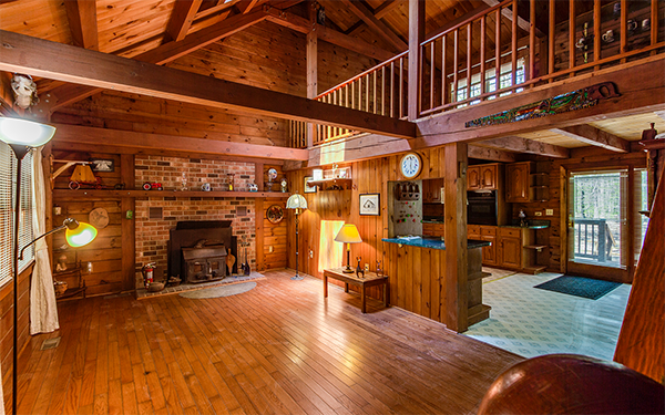
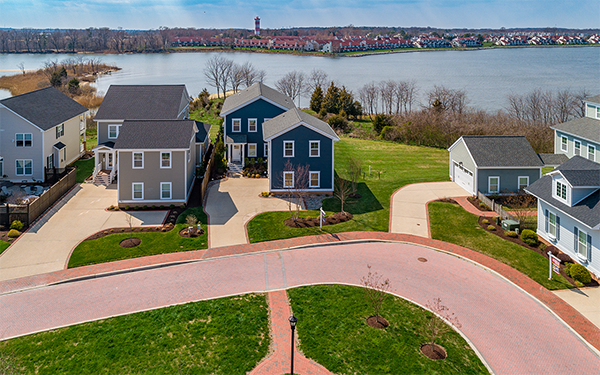
Get an edge in today's competetive real estate market with aerial photos and video. Aerial photos and videos allow realtors and homeowners an opportunity to showcase their property in the best light possible. We also offer full interior and exterior photo and video packages.

360° VR Walkthroughs

Put your clients right in the property! 360 ° walkthroughs can be viewed in your favorite virtual reality headset, google cardboard, and a normal computer or phone. We can deliver content in a variety of ways depending on your needs or we can host on our site for no additional fee. Check out an example here!

Infrastructure Inspection

Drones reduce risk of injury and cost for a wide range of applicatioins. Roofs, water & cellular towers, bridges, and other hard to reach places can be accessed from a variety of angles to provide thorough detailed information. We deliver high resolution images that allow clients to feel confident in thier analysis.

Crop Inspection

Drones are a new, high-precision way to obtain geo-tagged images from the air. Compared with other aerial survey methods, drones generate more precise and more frequent data about the condition of crops. This data is used in many ways to improve the performance of a farm’s operation. For surveying fields of less than 50 hectares in size, drones are cheaper than manned aircraft surveillance, manned scouting and satellite imaging.

About


Licensed and Fully Insured

The Federal Aviation Association (FAA) requires proper licensing for all comercial unmanned aerial systems (UAS). operations. Io Aerial is FAA Part 107 compliant and all of our UAS operators hold a remote pilot certificate with a small UAS rating.

Experienced

The team at Io Aerial has broad experience in the aviatioin industry providing instruction, managment and maintenence for over 20 years. This experience provides an extensive foundation to conduct safe flight operations.

Aerial Drone Photography Maryland

Real Estate Pricing


See here for our most common pricing packages. Delivery will typically occur within 24hrs via digital file transfer.
For other projects such as cinematography or inspections, please contact us so we can discuss your needs.

Aerial HD Photos

$150
  • 5-10 HD photos
  • Professionally Edited and Color Corrected

Interior & Aerial HDR Package

$250
  • 5-10 Aerial & 20-30 Interior Photos
  • Professionally Edited & Color Corrected
  • Up to 2,000 ft2
  • $25 Each Additional 1k ft2 Bracket

Aerial HD Video

$200
  • Approximate 1 minute duration
  • Professionally Edited with Music
  • Available in 1080 & 4k

Photo & Video Bundle

$350
  • Interior and Exterior HDR Photos
  • Exterior Aerial Video
  • Video Professionally Edited with Music
  • Up to 2,000 ft2
  • $25 Each Additional 1k ft2 Bracket

Virtual Tour

$250
  • 360° Walkthrough up to 2k ft2
  • HDR Professionally Edited Photos
  • 360° Web Hosting on IoAerial.com
  • $50 Each Additional 1k ft2 Bracket

Tour/Photo/Video Bundle

$500
  • 360° Walkthrough up to 2,000 ft2)
  • Interior and Exterior Edited HDR Photos
  • Exterior Aerial Video
  • 360°Web Hosting on IoAerial.com
  • $50 Each Additional 1k ft2 Bracket

Contact Us